Εμφάνιση αναρτήσεων με ετικέτα R/C. Εμφάνιση όλων των αναρτήσεων

Τρίτη 18 Σεπτεμβρίου 2012

REMOTE CONTROLLED CAMERA ARRAY

I really like remote controlled cameras. Unfortunatelly, affordable ones are very rare these days (like Pentax Optio S1) . An infrared remote control was considered standard accessory during the good old days of  mini-dv and other  tape camcorders but now one has to try hard to find the little red-purple  piece of plastic at the front face of contemporary video equipment.
So,I  decided to make an arduino infrared remote controlled camera array . An arduino prototype board with an infrared led and two servos controls at least four different pieces of video equipment and has a few  options useful for nature and wild life photography as well.  A motorized camera rig is on the way.
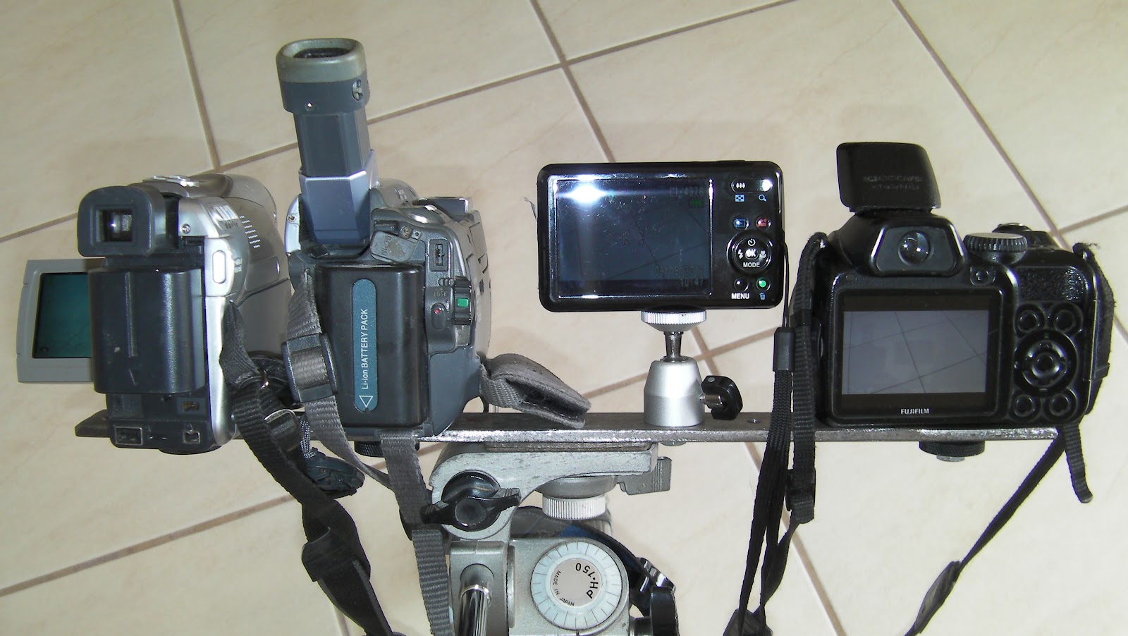
Oblique view of the  camera array

Rear view of the camera array
Camera array in action


Arduino sends infrared remote codes to the cameras in order to control functions like shutter press/release, zoom in /out, snapshot recording and video recording toggle. Arduino infrared is controlled remotely by either by a  PWM R/C remote control , a serial  digital link (or Xbee) ,  a 433MHZ 4-Channel  button remote control or locally using butons on the arduino board itself. Even two servos can be connected on the board to control shutter and zoom in manual-only cameras. A relay output and an user configurable input can be connected to a PIR detector or an infrared barrier.
A "hacked" 433MHZ radio link -we just get TTL Rx/Tx signals and 5V to feed  Arduino

Arduino infrared prototype feeded by a  7.4V  LiPo (5400mah!!) , a 3A/ 5V swiching regulator, and a hacked 433Mhz serial link . Bottom center is the Infrared led and one of the two optional servos for shutter and zoom functions.  

The not-so-innocent cheap helicopter model remote control and hacked  433Mhz serial receiver. Everything inside original remote  was discarded and a 433Mhz serial link (the same as the receiver) was added  together with an arduino mini at 16 Mhz, another  two axis left joystick and two extra buttons below it.  Power comes from  4 NimH batteries and a 5V/3A switching regulator,  Line-of-view range is about 300 meters.  

Arduino infrared prototype is controlled by an -also hacked - 4-channel 433 Mhz garage door  receiver. The minimalistic remote shown on the right has a line-of-view range of 300 meters ! It can control shutter , Video recording and Zoom functions of every camera in  the array.   

 2 channels of a common  PWM R/C receiver are connected to the arduino prototype. We can control  shutter , Video recording and Zoom functions of every camera in  the array also,  using flap  (CH6) switch for shutter and Video record toggle, and  throttle (or elevator) joystick (CH3/CH1) for Zooming functions.     

Another useful option is the built-in intervalometer   which takes time-lapse videos like this one :

You can see a FHD of the above video if you click on the following  link :
or this one :


Δευτέρα 5 Σεπτεμβρίου 2011

DRAGON BOAT

Dragon boat is a wooden speed boat model made in Japan at late 50's.  Japan's  economy was trying to recover from WWII  and toy companies (like Ito) used Japanese households to assemble their products  like this one. My grandfather who was a sailor gave  it as a present to his son (my late uncle) and my first thought was to use it to tow the depth sounder platform in order to accomplish some lake topography and bathymetry missions. Later I discovered (the hard way ) that these thoughts were disastrous for the boat model and potentially dangerous for me.
The Dragon that gave the name to this model was once painted on both sides of the boat. Unfortunately it was so worn-out that I had to wipe it out completely.
Anyway,  I made an ESC with a picaxe and two mosfets and I used a standard servo for steering. The 35MHZ receiver antenna is visible on the following images


Here is a rather shaky  video. I'm sorry for this  but it 's quite difficult to take video and pilot  the model simultaneously.


AUTONOMOUS - REMOTE CONTROLLED VEHICLE

It s a simple implementation of ardupilot ver 1.0 with a few add-ons. FTDI usb to serial interface is used to program the ardupilot, an RF data link at 9600baud transmitts positioning and other data , and standard 35 MHZ r/c equipment is used for vehicle control and activation of autopilot. Oziexplorer is used as the logging and  mapping interface (for real time position indication) via  a simple trick : Distance to home (to launch point) is injected into GGA  NMEA  sequence instead of altiude (by regenerating the sequence and transmitting it via rf )
Unfortunately due to the complete lack of suspension  and because of the ultra simple steering mechanism of the extremely cheap (6 euro's ) jeep model, when  RTL (Return To Launch) function was implemented, it  produced a funny track to home as shown in the last capture from Ozi interface.


The implementation of RTL function


AUTONOMOUS / REMOTE CONTROLLED WATER RESERVOIR SURVEY


Another implementation of arduino micro-controller auto pilot is the lake surveying  ROV . The main advantage of such an implementation is that ,the greatest percentage of lake area has depths less than 1/2 meter and so it's quite impossible to measure it using conventional depth sounding techniques.
A motorized (via a Graupner outboard motor) plywood platform on 2 cylindrical  floats (catamaran style),  with just 5 cm drought fits the task ,  with plenty of electronics on board such as:
  • A picaxe ESC (electronic speed control)
  • A standard 4 channel r/c receiver at 35 MHZ
  • An Arduino board with Em406 GPS 
  • An intelligent depth sounder (with rs232 output)
  • A 433MHZ 9600 baud telemetry transmitter  or an XBee pro link at 900MHZ.
      and for the monitoring station:
  • A laptop that runs Winxp and Oziexplorer (my favorite mapping program)
  • An underwater  camera with video link (for clearing underwater obstructions) 
  • A laptop for data logging - real time position indication -video capture


Surveying ROV with Gps , Autopilot, RF data link and depth sounder

Quite a big team is required for such a project. You may need :

  • a 4x4 truck
  • a driver
  • a diver
  • a cameraman
  • a computer IT expert
  • an electronics engineer
  • a Photographer
  • a GIS expert
  • a computer graphics / desktop publishing expert
  • Logging , mapping , GIS , video authoring and  Desktop publishing software 
  • a sponsor
But the results can  be rewarding as shown in the following images :

Survey results

Survey results

REMOTE CONTROLLED KITE AERIAL PHOTOGRAPHY

Aerial photography is implemented via an r/c kite - suspended pan tilt rig ,and an rf video link. Kite aerial photography is completely  different  from  traditional r/c model photography. It has some serious advantages as :
  • Low cost
  • Low risk for environment, operator and subject
  • Completely portable. (whole set fits in a 40 lt backpack)
  • Easy maintenance.
  • Quiet and low profile.
  • One person operation , remote operation possible. 
Main drawbacks are :
  • Wind must have a speed  over 12 knots (>4 beaufort scale) - not a problem at  the Aegean islands.
  • Kite line must be clear of electric lines, trees and other obstacles.
The kite can be a fully foldable one (no spars) of the flowform type but virtually any type with a 2-3m2 area can be used..
The spool (reel) is the most critical part of the system , because it must take 150-400m of line, it must have a kind of brake ( and that is very important!) and a handle that can wind and release the line fast . Mine is hand  made of 10mm plywood.
The rig is suspended on a picavet style cross from the line below the kite (as a safety measure) ,it weights approx 500grams  and it consists of:
  • a 2mm  aluminum frame with 4mm ball bearings (from old floppy disk readers) 
  • 2 standard servos for pan and tilt (the pan servo must rotate 360deg )
  • A micro servo for the shutter button 
  • an rf video/audio link at 1.2GHZ  connected to tv out of the camera
  • a standard 3 channel r/c transmitter at 35 MHZ 
  • A high resolution digital camera (>9mpix) in wide angle mode, low weight
  • Batteries for all the above
kite, profile

kite and spool

kite and rig


Ancient stone heaps , Χουβέλες στο Αίπος

Ancient stone heaps , Χουβέλες στο Αίπος

Aquaduct over Koufos stream, Το υδραγωγείο στο ρέμα του  Κουφού

Chios landscape ,  Ανοιξιάτικο τοπίο


Δότια Χίου , Dotia Chios

Byzantine tower at Dotia ,Chios . Βυζαντινός πύργος στα Δότια

Anavatos - Chios  Ανάβατος Χίου
 Here is a low-resolution video from the aerial camera.